
What are Vertical Datums in Land Surveying?

Per the National Geodetic Survey here in the United States, the basic definition of a Vertical Datum is:
A surface of zero elevation to which heights of various points are referenced.
It may sound like a complex concept, however, in land surveying, a vertical datum is simply a starting point used to measure heights and depths of things like mountains, buildings, and oceans. Imagine you're playing a game of "How High Can You Jump?", like in the below graphic, and everyone has to start from the same line at the floor. That line is the vertical datum! It's a reference surface that helps us compare how high or low different places or things are, or in the case of the game, how high each person can jump.

Think of it as a giant ruler that goes up and down instead of side to side. Surveyors use the vertical datum to figure out elevations, like how tall a mountain is compared to sea level or how deep a lake is below the surface. It's important because it helps us understand the shape of the land and where things are in relation to each other, kind of like making a map but for heights instead of distances.
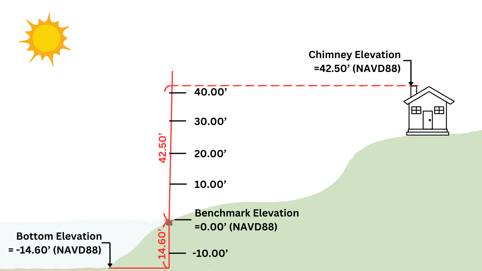
In the following image, you can see the shown benchmark at the edge of the water with an elevation of 0.00’. In this case the bottom bed of the water is -14.60’ below the benchmark and the chimney of the house is 42.50’ above the benchmark.
You may have noticed that on the elevations there is a (NAVD88) reference. This is one of many named datums that will often be referenced. When looking at elevations It is important to understand what the elevation is in reference to. Some may be based upon a published jurisdictional vertical datum, and some may be arbitrary to something close by that can simply be referenced for future measurements. For example, we could say the front right corner of your garage floor has an elevation of “0”. We then can use that point for any future measurements to know how high anything is above that point.
It is however important to have good published datums that can be referenced, that everyone can use. Let’s say you want to build a house near a lake and the lake surface elevation raises and lowers throughout the year and you want to make sure you build the house in an area that the lake can't possibly ever be in the lake. There will more than likely be extensive records throughout the years which will allow the max elevation to be determined, which will be in reference to some sort of a vertical datum. With that information you can have a Topographic Survey completed of your property to make sure you build your house well above the max elevation to be sure you will not end up in the lake.
For our more advanced readers, we will now go into a more detail regarding the most common named vertical datums within the US.
Named Vertical Datums:
In the United States, for the most part, these vertical datums have the average sea level represented at an elevation of 0.00’. The North American Vertical Datum of 1988 (NAVD88) is the current vertical datum for the contiguous United States and Alaska. However, you may also come across other datums like the Sea Level Datum of 1929, National Geodetic Vertical Datum of 1929 (NGVD29), assumed datums, and local jurisdictional datums.
The Sea Level Datum of 1929, renamed in 1973 as the National Geodetic Vertical Datum of 1929, was established through a general adjustment in 1929. This datum used the observed heights of mean sea level at 26 tide gauges, fixing mean sea level at those sites and defining the elevation of bench marks. However, it was not mean sea level, the geoid, or any other equipotential surface, prompting the name change in 1973.
NAVD88, established in 1991, is the result of a minimum-constraint adjustment of leveling observations across Canada, Mexico, and the United States. It is crucial in the National Spatial Reference System (NSRS) for the Conterminous United States and Alaska, providing a consistent reference point across the continent.
As part of the ongoing efforts to replace the existing NAD 83 reference frames, the National Geodetic Survey (NGS) is working on a new gravity-based vertical datum known as the North American-Pacific Geopotential Datum of 2022 (NAPGD2022). This datum, accurate at the 2 cm level for much of the country, is a significant development in land surveying.
With the introduction of NAPGD2022, we are facing a third major datum change. This means that land surveyors will need to adapt to this new standard, ensuring accurate measurements and reference points. While many states are already gearing up to adopt this more precise datum, it's essential to check local project jurisdictional requirements, as some areas will continue to use NAVD88 or NGVD29.
As we witness advancements in land surveying technology, the evolution of vertical datums plays a pivotal role in ensuring accuracy and consistency. The upcoming North American-Pacific Geopotential Datum of 2022 brings exciting prospects for improved precision, but it also means that we, as professionals and enthusiasts, must stay informed and adaptable to the changing landscape of land surveying. Stay tuned for the release of NAPGD2022, as it promises to reshape the way we measure and reference heights.